| Whitfield
County Tax Parcel Information |
|
Owner and Parcel
Information
|
| Parcel Number |
10-039-03-000 |
| Realkey |
1706 |
| Property
Record Card |
Click Here |
| GIS Map |
Map |
| Owner Name |
MCDONALD E CRAWFORD |
| Owner Address |
P O BOX 1444 |
| Owner Address 2 |
|
| Owner Address 3 |
|
| Owner City |
DALTON |
| Owner State |
GA |
| Owner Zip |
30722 |
| Latitude |
34.96978426 |
| Longitude |
-84.8630987 |
|
| Property
Information |
| Class |
Residential |
| Strata |
Large Tract |
| Tax District |
County |
| Neighborhood |
|
| Legal Description |
TR6, 7, 8, 9 & 10 JOHN E DAVIS ETAL |
| Total Acres |
48.02 |
| Zoning |
See GIS Map |
| GMD\Map Number |
140 |
| Subdivision |
|
| Subdivision Phase |
|
| Subdivision Section |
0005 |
| Subdivision Block |
|
| Subdivision Lot |
|
| Comments: |
|
|
| Appeals
Information |
| Appeal Year |
2016 |
| Appeal Status |
Resolved |
| Appeal Year |
2023 |
| Appeal Status |
Resolved |
|
|
|
| Parcel
Address |
| Parcel House Number |
0 |
| Parcel Street Extension |
|
| Parcel Street Direction |
E |
| Parcel Street Name |
EMERSON |
| Parcel Street Units |
|
| Parcel Street Type |
RD |
|
| Current
Fair Market Value Information |
| Previous |
118864 |
| Current |
127650 |
| Land |
127650 |
| Residential Improvement |
|
| Commercial Improvement |
|
| Accessory Improvement |
|
| Conservation Use Value |
|
|
| Historical
Fair Market Value Information |
| 2023 |
166534 |
| 2022 |
140027 |
| 2021 |
140027 |
|
| Exemption
Information |
| Homestead |
S0 |
| Preferential Year |
|
| Conservation Use Year |
|
| Historical Year |
|
| Historical Val |
0 |
| EZ year |
|
| EZ Val |
0 |
|
|
 |
|
|
| GIS Quickmap |
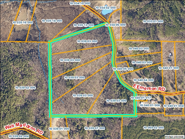 |
| For the current GIS map of this parcel, click on the Quickmap to launch the interactive map viewer
|
|
|
|
| Tax Commissioner Information
|
| Before making payment verify the amount due with the Tax Commissioner s office at 706-275-7510
|
| Tax Bill Recipient |
MCDONALD E CRAWFORD |
| Year |
2025 |
| Parcel Number |
10-039-03-000 |
| Bill |
224547 |
| Exemption Type |
|
| Account No. |
23365 |
| Millage Rate |
0 |
| Fair Market Value |
127650 |
| Assessed Value |
51060 |
| Prior Years Tax Data |
Tax |
|
| Legal Description |
TR6, 7, 8, 9 & 10 JOHN E DAVIS ETAL |
| Sale Date |
|
| Taxes Due |
1124.14 |
| Taxes Due Date |
1/20/2026 |
| Taxes Paid |
1124.14 |
| Taxes Paid Date |
12/22/2025 10:45:15 AM |
| Current Due |
0 |
| Back Taxes |
0 |
| Total Due |
0 |
| |
|
|
|
|
| Commercial Structure
Information
|
|
|
| This parcel does not have any commercial structures to display |
|
| Residential Structure
Information
|
|
|
| This
parcel does not have any residential structures to display |
|
| Accessory
Information |
|
|
| This
parcel does not have any accessories to display |
|
| Sales
Information |
| Grantee |
MCDONALD E CRAWFORD |
| Grantor |
KELLY JENICE MOREHEAD |
| Sale Price |
100000 |
| Sale Date |
7/3/2000 |
| Deed Book/Page |
3297 286 |
| Deed Link |
Click Here |
|
| Class |
Residential |
| Strata |
No Land |
| Reason |
FAIR MARKET VACANT SALE |
| State |
N |
| PT-61 |
|
| Comments |
WARRANTY DEED INCL: 10-039-04-000, 10-039-05-000, |
|
|
| Grantee |
MCDONALD E CRAWFORD |
| Grantor |
KELLY JENICE MOREHEAD |
| Sale Price |
100000 |
| Sale Date |
7/3/2000 |
| Deed Book/Page |
3297 286 |
| Deed Link |
Click Here |
|
| Class |
Residential |
| Strata |
Large Tract |
| Reason |
MULTIPLE PARCELS INCLUDED IN SALE (FM) |
| State |
N |
| PT-61 |
-000000 |
| Comments |
WARRANTY DEED INCL: 10-039-04-000, 10-039-05-000, |
|
|
| Grantee |
KELLY JENICE MOREHEAD |
| Grantor |
KELLY JERRY W |
| Sale Price |
0 |
| Sale Date |
6/19/1998 |
| Deed Book/Page |
2992 248 |
| Deed Link |
Click Here |
|
| Class |
Residential |
| Strata |
Small Tract |
| Reason |
LEGAL/DIVORCE/LAWSUITS/ETC |
| State |
N |
| PT-61 |
-000000 |
| Comments |
CIVIL ACTION 68978-P |
|
|
| Grantee |
KELLY JENICE MOREHEAD |
| Grantor |
|
| Sale Price |
0 |
| Sale Date |
6/1/1998 |
| Deed Book/Page |
2992 248 |
| Deed Link |
Click Here |
|
| Class |
Residential |
| Strata |
Small Tract |
| Reason |
|
| State |
N |
| PT-61 |
|
| Comments |
|
|
|
|
|
 |