| Whitfield
County Tax Parcel Information |
|
Owner and Parcel
Information
|
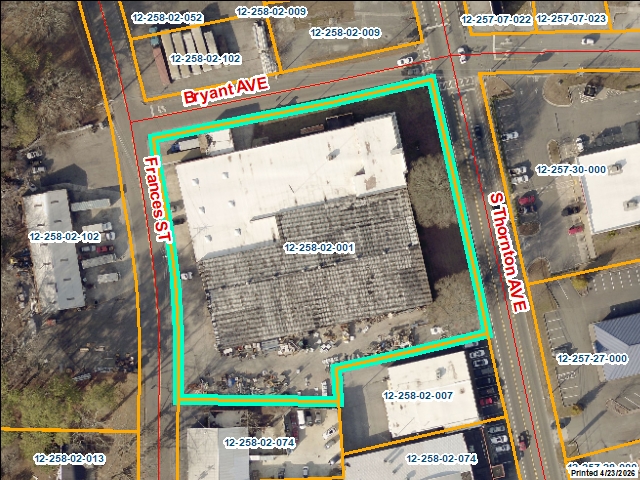
| Parcel Number |
12-258-02-001 |
| Realkey |
24313 |
| Property
Record Card |
Click Here |
| Property
Record Card |
Click Here |
| GIS Map |
Map |
| Owner Name |
M DAVID & ASSOC INC |
| Owner Address |
P O BOX 1049 |
| Owner Address 2 |
|
| Owner Address 3 |
|
| Owner City |
DALTON |
| Owner State |
GA |
| Owner Zip |
30722 |
| Latitude |
34.75714868 |
| Longitude |
-84.97028018 |
|
| Property
Information |
| Class |
Commercial |
| Strata |
Lot |
| Tax District |
City of Dalton |
| Neighborhood |
WH COM |
| Legal Description |
LTS 1,2,12,13, PT LT 3, & UNNUM. LT |
| Total Acres |
1.78 |
| Zoning |
See GIS Map |
| GMD\Map Number |
83 |
| Subdivision |
|
| Subdivision Phase |
|
| Subdivision Section |
0009 |
| Subdivision Block |
|
| Subdivision Lot |
|
| Comments: |
|
|
| Appeals
Information |
|
|
| This
parcel does not have any appeals
|
|
|
|
| Parcel
Address |
| Parcel House Number |
1000 |
| Parcel Street Extension |
|
| Parcel Street Direction |
S |
| Parcel Street Name |
THORNTON |
| Parcel Street Units |
|
| Parcel Street Type |
AVE |
|
| Current
Fair Market Value Information |
| Previous |
1342646 |
| Current |
1342646 |
| Land |
267000 |
| Residential Improvement |
|
| Commercial Improvement |
1075646 |
| Accessory Improvement |
|
| Conservation Use Value |
|
|
| Historical
Fair Market Value Information |
| 2023 |
889630 |
| 2022 |
564621 |
| 2021 |
564621 |
|
| Exemption
Information |
| Homestead |
S0 |
| Preferential Year |
|
| Conservation Use Year |
|
| Historical Year |
|
| Historical Val |
0 |
| EZ year |
|
| EZ Val |
0 |
|
|
 |
|
|
| GIS Quickmap |
 |
| For the current GIS map of this parcel, click on the Quickmap to launch the interactive map viewer
|
|
|
|
| Tax Commissioner Information
|
| Before making payment verify the amount due with the Tax Commissioner s office at 706-275-7510
|
| Tax Bill Recipient |
M DAVID & ASSOC INC |
| Year |
2025 |
| Parcel Number |
12-258-02-001 |
| Bill |
223152 |
| Exemption Type |
|
| Account No. |
7053812 |
| Millage Rate |
0 |
| Fair Market Value |
1342646 |
| Assessed Value |
537058 |
| Prior Years Tax Data |
Tax |
|
| Legal Description |
LTS 1,2,12,13, PT LT 3, & UNNUM. LT |
| Sale Date |
|
| Taxes Due |
15444.45 |
| Taxes Due Date |
1/20/2026 |
| Taxes Paid |
15444.45 |
| Taxes Paid Date |
12/16/2025 10:33:53 AM |
| Current Due |
0 |
| Back Taxes |
0 |
| Total Due |
0 |
| |
|
|
|
|
| Commercial Structure
Information
|
| General |
| Improvement Number |
1 |
| Section Number |
1 |
| Sketch |
Click Here |
| Class |
Commercial |
| Strata |
Improvement |
| Built As |
*Warehouse Commercial |
| Used As |
*Warehouse Commercial |
| Grade |
100 |
| Physical Depreciation |
0.5 |
| Structure value |
1047838 |
| Section Value |
1075646 |
| Total Improvement Value |
1075646 |
| Comments: |
|
|
| Construction Information |
| Construction Type |
Reinforced Concrete |
| Wall Height |
16 |
| Year Built |
1958 |
| Effective Year Built |
1967 |
| Section Area |
42175 |
| Total Building Area |
42175 |
| Plumbing |
| One Fixture |
0 |
| Two Fixture |
2 |
| Three Fixture |
0 |
| Bath\Kitchen |
0 |
| 1.5 Bath\Kitchen |
0 |
| 2 Bath\Kitchen |
0 |
|
|
|
|
|
| Residential Structure
Information
|
|
|
| This
parcel does not have any residential structures to display |
|
| Accessory
Information |
|
|
| This
parcel does not have any accessories to display |
|
| Sales
Information |
| Grantee |
M DAVID & ASSOC INC |
| Grantor |
COHUTTA BANKING COMPANY |
| Sale Price |
510000 |
| Sale Date |
6/20/2008 |
| Deed Book/Page |
5225 19 |
| Deed Link |
Click Here |
|
| Class |
Commercial |
| Strata |
Improvement |
| Reason |
|
| State |
N |
| PT-61 |
PT-61 155-2008-000000 |
| Comments |
LIMITED WARRANTY DEED
SALE PRICE ALSO INCLUDES 12 |
|
|
| Grantee |
COHUTTA BANKING COMPANY |
| Grantor |
WOOD LAWRENCE RICHARD |
| Sale Price |
775000 |
| Sale Date |
4/1/2008 |
| Deed Book/Page |
5192 256 |
| Deed Link |
Click Here |
|
| Class |
Commercial |
| Strata |
Improvement |
| Reason |
|
| State |
N |
| PT-61 |
PT-61 155-2008-000000 |
| Comments |
DEED UNDER POWER OF SALE
INCLUDES 12-258-02-102
|
|
|
| Grantee |
WOOD LAWRENCE RICHARD |
| Grantor |
EXCEL SAMPLE INC |
| Sale Price |
650000 |
| Sale Date |
9/8/2000 |
| Deed Book/Page |
3325 334 |
| Deed Link |
Click Here |
|
| Class |
Commercial |
| Strata |
Improvement |
| Reason |
|
| State |
N |
| PT-61 |
|
| Comments |
WARRANTY DEED |
|
|
| Grantee |
EXCEL SAMPLE INC |
| Grantor |
|
| Sale Price |
460000 |
| Sale Date |
1/1/1995 |
| Deed Book/Page |
2592 115 |
| Deed Link |
Click Here |
|
| Class |
Commercial |
| Strata |
Lot |
| Reason |
FAIR MARKET IMPROVED SALE |
| State |
N |
| PT-61 |
|
| Comments |
|
|
|
|
|
 |