| Whitfield
County Tax Parcel Information |
|
Owner and Parcel
Information
|
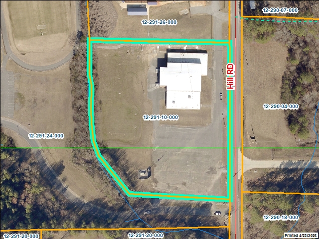
| Parcel Number |
12-291-10-000 |
| Realkey |
26574 |
| Property
Record Card |
Click Here |
| GIS Map |
Map |
| Owner Name |
WHITFIELD COUNTY |
| Owner Address |
301 W CRAWFORD STREET |
| Owner Address 2 |
|
| Owner Address 3 |
|
| Owner City |
DALTON |
| Owner State |
GA |
| Owner Zip |
30720 |
| Latitude |
34.74603076 |
| Longitude |
-84.92833693 |
|
| Property
Information |
| Class |
Exempt |
| Strata |
Public Property |
| Tax District |
County |
| Neighborhood |
|
| Legal Description |
11.17A EASTBROOK HIGH |
| Total Acres |
4.92 |
| Zoning |
See GIS Map |
| GMD\Map Number |
109 |
| Subdivision |
|
| Subdivision Phase |
|
| Subdivision Section |
0004 |
| Subdivision Block |
|
| Subdivision Lot |
|
| Comments: |
|
|
| Appeals
Information |
|
|
| This
parcel does not have any appeals
|
|
|
|
| Parcel
Address |
| Parcel House Number |
700 |
| Parcel Street Extension |
|
| Parcel Street Direction |
|
| Parcel Street Name |
HILL |
| Parcel Street Units |
|
| Parcel Street Type |
RD |
|
| Current
Fair Market Value Information |
| Previous |
540713 |
| Current |
540713 |
| Land |
103320 |
| Residential Improvement |
|
| Commercial Improvement |
437393 |
| Accessory Improvement |
|
| Conservation Use Value |
|
|
| Historical
Fair Market Value Information |
| 2023 |
1131761 |
| 2022 |
1131731 |
| 2021 |
1131731 |
|
| Exemption
Information |
| Homestead |
S0 |
| Preferential Year |
|
| Conservation Use Year |
|
| Historical Year |
|
| Historical Val |
0 |
| EZ year |
|
| EZ Val |
0 |
|
|
 |
|
|
| GIS Quickmap |
 |
| For the current GIS map of this parcel, click on the Quickmap to launch the interactive map viewer
|
|
|
|
| Tax Commissioner Information
|
| Before making payment verify the amount due with the Tax Commissioner s office at 706-275-7510
|
| Tax Bill Recipient |
WHITFIELD COUNTY |
| Year |
2025 |
| Parcel Number |
12-291-10-000 |
| Bill |
240370 |
| Exemption Type |
|
| Account No. |
7078243 |
| Millage Rate |
0 |
| Fair Market Value |
540713 |
| Assessed Value |
0 |
| Prior Years Tax Data |
Tax |
|
| Legal Description |
11.17A EASTBROOK HIGH |
| Sale Date |
|
| Taxes Due |
0 |
| Taxes Due Date |
1/20/2026 |
| Taxes Paid |
0 |
| Taxes Paid Date |
|
| Current Due |
0 |
| Back Taxes |
0 |
| Total Due |
0 |
| |
|
|
|
|
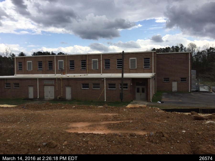
| Commercial Structure
Information
|
| General |
| Improvement Number |
2 |
| Section Number |
1 |
| Sketch |
Click Here |
| Class |
Exempt |
| Strata |
Public Property |
| Built As |
Gymnaziums |
| Used As |
Gymnaziums |
| Grade |
100 |
| Physical Depreciation |
0.18 |
| Structure value |
256130 |
| Section Value |
256130 |
| Total Improvement Value |
437393 |
| Comments: |
|
|
| Construction Information |
| Construction Type |
Masonry Load Bearing Walls |
| Wall Height |
28 |
| Year Built |
1970 |
| Effective Year Built |
1980 |
| Section Area |
11340 |
| Total Building Area |
22455 |
| Plumbing |
| One Fixture |
0 |
| Two Fixture |
0 |
| Three Fixture |
0 |
| Bath\Kitchen |
0 |
| 1.5 Bath\Kitchen |
0 |
| 2 Bath\Kitchen |
0 |
|
|
|
| General |
| Improvement Number |
2 |
| Section Number |
2 |
| Sketch |
Click Here |
| Class |
Exempt |
| Strata |
Public Property |
| Built As |
Shower Room Bldg |
| Used As |
Shower Room Bldg |
| Grade |
100 |
| Physical Depreciation |
0.19 |
| Structure value |
80800 |
| Section Value |
80800 |
| Total Improvement Value |
437393 |
| Comments: |
|
|
| Construction Information |
| Construction Type |
Masonry Load Bearing Walls |
| Wall Height |
14 |
| Year Built |
1970 |
| Effective Year Built |
1980 |
| Section Area |
6090 |
| Total Building Area |
22455 |
| Plumbing |
| One Fixture |
0 |
| Two Fixture |
0 |
| Three Fixture |
0 |
| Bath\Kitchen |
0 |
| 1.5 Bath\Kitchen |
0 |
| 2 Bath\Kitchen |
0 |
|

|
|
| General |
| Improvement Number |
2 |
| Section Number |
3 |
| Sketch |
Click Here |
| Class |
Exempt |
| Strata |
Public Property |
| Built As |
Fieldhouses |
| Used As |
Fieldhouses |
| Grade |
100 |
| Physical Depreciation |
0.18 |
| Structure value |
100463 |
| Section Value |
100463 |
| Total Improvement Value |
437393 |
| Comments: |
|
|
| Construction Information |
| Construction Type |
Masonry Load Bearing Walls |
| Wall Height |
12 |
| Year Built |
1970 |
| Effective Year Built |
1980 |
| Section Area |
5025 |
| Total Building Area |
22455 |
| Plumbing |
| One Fixture |
0 |
| Two Fixture |
0 |
| Three Fixture |
0 |
| Bath\Kitchen |
0 |
| 1.5 Bath\Kitchen |
0 |
| 2 Bath\Kitchen |
0 |
|

|
|
|
|
| Residential Structure
Information
|
|
|
| This
parcel does not have any residential structures to display |
|
| Accessory
Information |
|
|
| This
parcel does not have any accessories to display |
|
| Sales
Information |
|
|
| This
parcel does not have any sales to display |
|
 |