| Whitfield
County Tax Parcel Information |
|
Owner and Parcel
Information
|
| Parcel Number |
12-351-03-001 |
| Realkey |
29526 |
| Property
Record Card |
Click Here |
| GIS Map |
Map |
| Owner Name |
DALTON WHITFIELD COUNTY JOINT |
| Owner Address |
DEVELOPMENT AUTHORITY |
| Owner Address 2 |
100 S HAMILTON ST |
| Owner Address 3 |
|
| Owner City |
DALTON |
| Owner State |
GA |
| Owner Zip |
30720 |
| Latitude |
34.72373045 |
| Longitude |
-84.97233538 |
|
| Property
Information |
| Class |
Residential |
| Strata |
Large Tract |
| Tax District |
County |
| Neighborhood |
|
| Legal Description |
L50,51,53 & PT L52 H C SMITH |
| Total Acres |
20.61 |
| Zoning |
See GIS Map |
| GMD\Map Number |
085 |
| Subdivision |
|
| Subdivision Phase |
|
| Subdivision Section |
0004 |
| Subdivision Block |
|
| Subdivision Lot |
|
| Comments: |
|
|
| Appeals
Information |
|
|
| This
parcel does not have any appeals
|
|
|
|
| Parcel
Address |
| Parcel House Number |
0 |
| Parcel Street Extension |
|
| Parcel Street Direction |
|
| Parcel Street Name |
BRICKYARD |
| Parcel Street Units |
|
| Parcel Street Type |
RD |
|
| Current
Fair Market Value Information |
| Previous |
430883 |
| Current |
736835 |
| Land |
736835 |
| Residential Improvement |
|
| Commercial Improvement |
|
| Accessory Improvement |
|
| Conservation Use Value |
|
|
| Historical
Fair Market Value Information |
| 2023 |
302426 |
| 2022 |
89558 |
| 2021 |
89558 |
|
| Exemption
Information |
| Homestead |
S0 |
| Preferential Year |
|
| Conservation Use Year |
|
| Historical Year |
|
| Historical Val |
0 |
| EZ year |
|
| EZ Val |
0 |
|
|
 |
|
|
| GIS Quickmap |
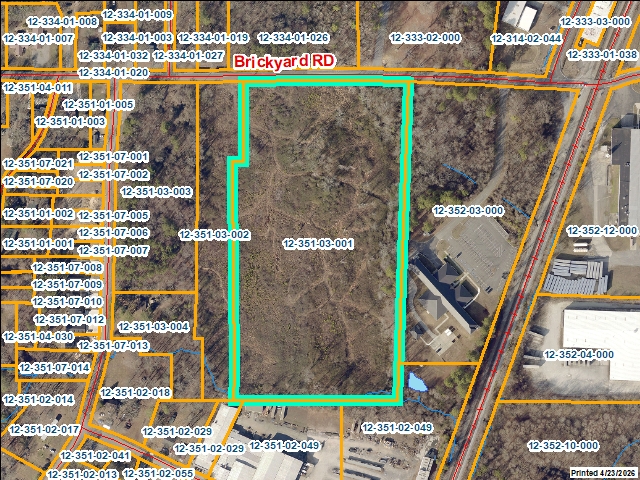 |
| For the current GIS map of this parcel, click on the Quickmap to launch the interactive map viewer
|
|
|
|
| Tax Commissioner Information
|
| Before making payment verify the amount due with the Tax Commissioner s office at 706-275-7510
|
| Tax Bill Recipient |
CAMERON BRICKYARD ID LLC |
| Year |
2025 |
| Parcel Number |
12-351-03-001 |
| Bill |
205899 |
| Exemption Type |
|
| Account No. |
7102347 |
| Millage Rate |
0 |
| Fair Market Value |
736835 |
| Assessed Value |
294734 |
| Prior Years Tax Data |
Tax |
|
| Legal Description |
L50,51,53 & PT L52 H C SMITH |
| Sale Date |
|
| Taxes Due |
6488.86 |
| Taxes Due Date |
1/20/2026 |
| Taxes Paid |
0 |
| Taxes Paid Date |
5/15/2026 11:33:50 AM |
| Current Due |
7076.91 |
| Back Taxes |
0 |
| Total Due |
7076.91 |
| |
|
|
|
|
| Commercial Structure
Information
|
|
|
| This parcel does not have any commercial structures to display |
|
| Residential Structure
Information
|
|
|
| This
parcel does not have any residential structures to display |
|
| Accessory
Information |
|
|
| This
parcel does not have any accessories to display |
|
| Sales
Information |
| Grantee |
DALTON WHITFIELD COUNTY JOINT |
| Grantor |
CAMERON BRICKYARD ID LLC |
| Sale Price |
0 |
| Sale Date |
11/21/2025 |
| Deed Book/Page |
7148 353 |
| Deed Link |
Click Here |
|
| Class |
Exempt |
| Strata |
Public Property |
| Reason |
SALE INVOLVING JOINT DEVELOPMENT AUTHORITY |
| State |
N |
| PT-61 |
PT-61 155-2025-003190 |
| Comments |
|
|
|
| Grantee |
CAMERON BRICKYARD ID LLC |
| Grantor |
GRATIAS MELISSA BERRY |
| Sale Price |
125000 |
| Sale Date |
9/30/2022 |
| Deed Book/Page |
6960 469 |
| Deed Link |
Click Here |
|
| Class |
Residential |
| Strata |
Small Tract |
| Reason |
SALE BETWEEN ADJACENT PARCEL OWNERS |
| State |
N |
| PT-61 |
PT-61 155-2022-003102 |
| Comments |
THIS DEED IS FOR ORIGINAL PARCEL 12-351-03-003 ONL |
|
|
| Grantee |
CAMERON BRICKYARD ID LLC |
| Grantor |
GRATIAS MELISSA BERRY |
| Sale Price |
0 |
| Sale Date |
9/30/2022 |
| Deed Book/Page |
6960 474 |
| Deed Link |
Click Here |
|
| Class |
Residential |
| Strata |
Large Tract |
| Reason |
SALE BETWEEN ADJACENT PARCEL OWNERS |
| State |
N |
| PT-61 |
PT-61 155-2022-003103 |
| Comments |
THIS DEED IS FOR ORIGINAL PARCEL 12-351-03-003 ONL |
|
|
| Grantee |
CAMERON BRICKYARD ID LLC |
| Grantor |
LAUREAH INVESTMENTS LLLP |
| Sale Price |
470100 |
| Sale Date |
9/30/2022 |
| Deed Book/Page |
6960 478 |
| Deed Link |
Click Here |
|
| Class |
Residential |
| Strata |
Large Tract |
| Reason |
SALE BETWEEN ADJACENT PARCEL OWNERS |
| State |
N |
| PT-61 |
PT-61 155-2022-003105 |
| Comments |
DEED IS FOR 12-351-03-001, 002, 005 |
|
|
| Grantee |
CAMERON BRICKYARD ID LLC |
| Grantor |
LAUREAH INVESTMENTS LLLP |
| Sale Price |
0 |
| Sale Date |
9/30/2022 |
| Deed Book/Page |
6960 483 |
| Deed Link |
Click Here |
|
| Class |
Residential |
| Strata |
Large Tract |
| Reason |
QUIT CLAIM |
| State |
N |
| PT-61 |
PT-61 155-2022-003106 |
| Comments |
DEED IS FOR 12-351-03-001, 002, 005 |
|
|
| Grantee |
LAUREAH INVESTMENTS LLLP |
| Grantor |
KEB GROUP LLC |
| Sale Price |
0 |
| Sale Date |
12/31/2019 |
| Deed Book/Page |
6758 140 |
| Deed Link |
Click Here |
|
| Class |
Residential |
| Strata |
Small Tract |
| Reason |
SALE BETWEEN RELATIVES OR CORP AFFILIATES |
| State |
N |
| PT-61 |
PT-61 155-2020-000575 |
| Comments |
SALE INCLUDES 12-351-03-01,12-351-03-02 AND 12-351 |
|
|
| Grantee |
KEB GROUP LLC |
| Grantor |
SYMARA FAMILY HOLDINGS&LAUREAH INVEST |
| Sale Price |
110000 |
| Sale Date |
4/24/2019 |
| Deed Book/Page |
6704 788 |
| Deed Link |
Click Here |
|
| Class |
Residential |
| Strata |
Small Tract |
| Reason |
MULTI ECONOMIC UNITS |
| State |
N |
| PT-61 |
PT-61 155-2019-001062 |
| Comments |
INCLUDES 12-351-03-001, -002 & -055 |
|
|
| Grantee |
SYMARA FAMILY HOLDINGS&LAUREAH INVEST |
| Grantor |
LAUEEAH LIMITED LLC |
| Sale Price |
0 |
| Sale Date |
11/1/2012 |
| Deed Book/Page |
5808 47 |
| Deed Link |
Click Here |
|
| Class |
Residential |
| Strata |
Large Tract |
| Reason |
|
| State |
N |
| PT-61 |
PT-61 155-2013-000000 |
| Comments |
THIS IS FOR THE 50% THAT KEN BORING OWNED AND GOIN |
|
|
| Grantee |
SYMARA FAMILY HOLDINGS LLLP |
| Grantor |
BORING MARITAL LLC |
| Sale Price |
0 |
| Sale Date |
3/16/2010 |
| Deed Book/Page |
5474 081 |
| Deed Link |
Click Here |
|
| Class |
Residential |
| Strata |
Small Tract |
| Reason |
|
| State |
N |
| PT-61 |
PT-61 155-2011-000000 |
| Comments |
INCL. ETAL |
|
|
| Grantee |
BORING MARITAL LLC |
| Grantor |
BORING SYBLE E |
| Sale Price |
0 |
| Sale Date |
3/15/2010 |
| Deed Book/Page |
5474 070 |
| Deed Link |
Click Here |
|
| Class |
Residential |
| Strata |
Small Tract |
| Reason |
|
| State |
N |
| PT-61 |
PT-61 155-2011-000000 |
| Comments |
INCL. ETAL |
|
|
| Grantee |
BORING SYBLE E |
| Grantor |
ROCCA LIMITED LLC |
| Sale Price |
0 |
| Sale Date |
3/12/2010 |
| Deed Book/Page |
5474 058 |
| Deed Link |
Click Here |
|
| Class |
Residential |
| Strata |
Small Tract |
| Reason |
|
| State |
N |
| PT-61 |
PT-61 155-2011-000000 |
| Comments |
INCL. ETAL |
|
|
| Grantee |
ROCCA LIMITED LLC |
| Grantor |
BORING JAMES MARCUS JR |
| Sale Price |
56700 |
| Sale Date |
1/1/2005 |
| Deed Book/Page |
4445 280 |
| Deed Link |
Click Here |
|
| Class |
Residential |
| Strata |
Small Tract |
| Reason |
|
| State |
N |
| PT-61 |
PT-61 155-2006-000000 |
| Comments |
INCL. 12-351-03-002 & 005 |
|
|
| Grantee |
LAUREAH INVEST LLC |
| Grantor |
BORING KENNETH EDWIN |
| Sale Price |
56700 |
| Sale Date |
3/19/2004 |
| Deed Book/Page |
4326 326 |
| Deed Link |
Click Here |
|
| Class |
Residential |
| Strata |
Large Tract |
| Reason |
|
| State |
N |
| PT-61 |
PT-61 155-2013-000000 |
| Comments |
THIS IS FOR THE 50% INTERESAT OF KEN BORING |
|
|
|
|
 |