| Whitfield
County Tax Parcel Information |
|
Owner and Parcel
Information
|
| Parcel Number |
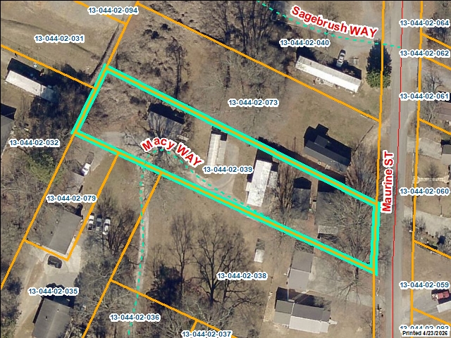
13-044-02-039 |
| Realkey |
31145 |
| Property
Record Card |
Click Here |
| GIS Map |
Map |
| Owner Name |
MCMURRAY BRENDA DIANE & PAUL |
| Owner Address |
P.O. BOX 6594 |
| Owner Address 2 |
|
| Owner Address 3 |
|
| Owner City |
DALTON |
| Owner State |
GA |
| Owner Zip |
30722 |
| Latitude |
34.70175736 |
| Longitude |
-84.98369393 |
|
| Property
Information |
| Class |
Residential |
| Strata |
Lot |
| Tax District |
County |
| Neighborhood |
STK |
| Legal Description |
L286T288 STARK SPRINGS |
| Total Acres |
0.57 |
| Zoning |
See GIS Map |
| GMD\Map Number |
062 |
| Subdivision |
|
| Subdivision Phase |
|
| Subdivision Section |
0006 |
| Subdivision Block |
|
| Subdivision Lot |
|
| Comments: |
|
|
| Appeals
Information |
| Appeal Year |
2003 |
| Appeal Status |
Resolved |
|
|
|
| Parcel
Address |
| Parcel House Number |
181 |
| Parcel Street Extension |
|
| Parcel Street Direction |
|
| Parcel Street Name |
MACY |
| Parcel Street Units |
|
| Parcel Street Type |
WAY |
|
| Current
Fair Market Value Information |
| Previous |
104972 |
| Current |
120853 |
| Land |
18500 |
| Residential Improvement |
101303 |
| Commercial Improvement |
|
| Accessory Improvement |
1050 |
| Conservation Use Value |
|
|
| Historical
Fair Market Value Information |
| 2023 |
59328 |
| 2022 |
44483 |
| 2021 |
13088 |
|
| Exemption
Information |
| Homestead |
S0 |
| Preferential Year |
|
| Conservation Use Year |
|
| Historical Year |
|
| Historical Val |
0 |
| EZ year |
|
| EZ Val |
0 |
|
|
 |
|
|
| GIS Quickmap |
 |
| For the current GIS map of this parcel, click on the Quickmap to launch the interactive map viewer
|
|
|
|
| Tax Commissioner Information
|
| Before making payment verify the amount due with the Tax Commissioner s office at 706-275-7510
|
| Tax Bill Recipient |
MCMURRAY BRENDA DIANE & PAUL |
| Year |
2025 |
| Parcel Number |
13-044-02-039 |
| Bill |
224736 |
| Exemption Type |
|
| Account No. |
7042759 |
| Millage Rate |
0 |
| Fair Market Value |
120853 |
| Assessed Value |
48341 |
| Prior Years Tax Data |
Tax |
|
| Legal Description |
L286T288 STARK SPRINGS |
| Sale Date |
|
| Taxes Due |
1064.28 |
| Taxes Due Date |
1/20/2026 |
| Taxes Paid |
1064.28 |
| Taxes Paid Date |
12/30/2025 11:14:37 AM |
| Current Due |
0 |
| Back Taxes |
0 |
| Total Due |
0 |
| |
|
|
|
|
| Commercial Structure
Information
|
|
|
| This parcel does not have any commercial structures to display |
|
| Residential Structure
Information
|
| General |
| Value |
101303 |
| Class |
Residential |
| Strata |
Improvement |
| Occupancy |
Single Family Residence |
| Year Built |
1960 |
| Observed Condition |
Average |
| Heated Area |
744 |
| Structure Sketch |
Click Here |
| Comments: |
|
| Plumbing |
| Full Baths |
1 |
| Half Baths |
0 |
| Standard Complements |
1 |
| Extra Features |
0 |
|
| Construction Information |
| Foundation |
Slab |
| Exterior Walls |
Vinyl |
| Roofing |
Asphalt Shingle |
| Roof Shape |
Gable/Hip |
| Floor Construction |
Cont. Wall |
| Floor Finish |
Carpet/Wood |
| Interior Wall |
Sheetrock/Drywall |
| Interior Ceiling |
Sheetrock |
| Heat |
Central Htg and Air |
| Story Height |
1 STORY |
| Basement/Attic
Information |
| Basement Description |
None |
| Basement Finish |
|
| Attic Description |
No Attic |
|
 |
|
|
|
| Accessory
Information |
| Description |
CARPORT |
| Value |
50 |
| Year Built |
1996 |
| Calculated Area |
240 |
|
| Length |
12 |
| Width |
20 |
| Class |
Residential |
| Strata |
Production/Storage/Auxiliary |
|
|
| Description |
STORAGE |
| Value |
1000 |
| Year Built |
2002 |
| Calculated Area |
528 |
|
| Length |
16 |
| Width |
33 |
| Class |
Residential |
| Strata |
Production/Storage/Auxiliary |
|
|
|
|
| Sales
Information |
| Grantee |
MCMURRAY BRENDA DIANE & PAUL |
| Grantor |
JOHNSON RONALD GLENN |
| Sale Price |
150000 |
| Sale Date |
2/23/2005 |
| Deed Book/Page |
4441 340 |
| Deed Link |
Click Here |
|
| Class |
Residential |
| Strata |
Improvement |
| Reason |
|
| State |
N |
| PT-61 |
PT-61 155-2006-000000 |
| Comments |
INCL. 13-044-035, 038, 059, 062, 079, & 093 |
|
|
| Grantee |
MCMURRAY PAUL |
| Grantor |
MCMURRAY BRENDA DIANE |
| Sale Price |
0 |
| Sale Date |
2/23/2005 |
| Deed Book/Page |
4441 345 |
| Deed Link |
Click Here |
|
| Class |
Residential |
| Strata |
Improvement |
| Reason |
|
| State |
N |
| PT-61 |
PT-61 155-2006-000000 |
| Comments |
INCL. 13-044-02-035, 038, 059, 062, 079, & 093
FO |
|
|
| Grantee |
JOHNSON RONALD GLENN & MCMURRAY ETAL |
| Grantor |
JOHNSON MAMIE INEZ ESTATE ETAL |
| Sale Price |
0 |
| Sale Date |
7/2/2004 |
| Deed Book/Page |
4279 212 |
| Deed Link |
Click Here |
|
| Class |
Residential |
| Strata |
Improvement |
| Reason |
|
| State |
N |
| PT-61 |
PT-61 155-2004-000000 |
| Comments |
ETAL EXECUTORS JOHNSON RONADL BLENN & MCMURRAY BRE |
|
|
|
|
 |