| Whitfield
County Tax Parcel Information |
|
Owner and Parcel
Information
|
| Parcel Number |
13-044-02-093 |
| Realkey |
39630 |
| GIS Map |
Map |
| Owner Name |
MCMURRAY BRENDA DIANE & PAUL |
| Owner Address |
P.O. BOX 6594 |
| Owner Address 2 |
|
| Owner Address 3 |
|
| Owner City |
DALTON |
| Owner State |
GA |
| Owner Zip |
30722 |
| Latitude |
34.70113446 |
| Longitude |
-84.98285084 |
|
| Property
Information |
| Class |
Residential |
| Strata |
Lot |
| Tax District |
County |
| Neighborhood |
STK |
| Legal Description |
LOTS 361&362 STARK SPRINGS |
| Total Acres |
0.16 |
| Zoning |
See GIS Map |
| GMD\Map Number |
062 |
| Subdivision |
|
| Subdivision Phase |
|
| Subdivision Section |
0006 |
| Subdivision Block |
|
| Subdivision Lot |
|
| Comments: |
|
|
| Appeals
Information |
|
|
| This
parcel does not have any appeals
|
|
|
|
| Parcel
Address |
| Parcel House Number |
158 |
| Parcel Street Extension |
|
| Parcel Street Direction |
|
| Parcel Street Name |
MAURINE |
| Parcel Street Units |
|
| Parcel Street Type |
ST |
|
| Current
Fair Market Value Information |
| Previous |
18500 |
| Current |
18500 |
| Land |
18500 |
| Residential Improvement |
|
| Commercial Improvement |
|
| Accessory Improvement |
|
| Conservation Use Value |
|
|
| Historical
Fair Market Value Information |
| 2023 |
10000 |
| 2022 |
10000 |
| 2021 |
10000 |
|
| Exemption
Information |
| Homestead |
S0 |
| Preferential Year |
|
| Conservation Use Year |
|
| Historical Year |
|
| Historical Val |
0 |
| EZ year |
|
| EZ Val |
0 |
|
|
 |
|
|
| GIS Quickmap |
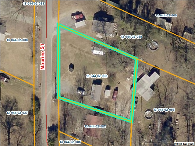 |
| For the current GIS map of this parcel, click on the Quickmap to launch the interactive map viewer
|
|
|
|
| Tax Commissioner Information
|
| Before making payment verify the amount due with the Tax Commissioner s office at 706-275-7510
|
| Tax Bill Recipient |
MCMURRAY BRENDA DIANE & PAUL |
| Year |
2025 |
| Parcel Number |
13-044-02-093 |
| Bill |
224741 |
| Exemption Type |
|
| Account No. |
7042759 |
| Millage Rate |
0 |
| Fair Market Value |
18500 |
| Assessed Value |
7400 |
| Prior Years Tax Data |
Tax |
|
| Legal Description |
LOTS 361&362 STARK SPRINGS |
| Sale Date |
|
| Taxes Due |
162.93 |
| Taxes Due Date |
1/20/2026 |
| Taxes Paid |
162.93 |
| Taxes Paid Date |
12/30/2025 11:14:37 AM |
| Current Due |
0 |
| Back Taxes |
0 |
| Total Due |
0 |
| |
|
|
|
|
| Commercial Structure
Information
|
|
|
| This parcel does not have any commercial structures to display |
|
| Residential Structure
Information
|
|
|
| This
parcel does not have any residential structures to display |
|
| Accessory
Information |
|
|
| This
parcel does not have any accessories to display |
|
| Sales
Information |
| Grantee |
MCMURRAY BRENDA DIANE & PAUL |
| Grantor |
JOHNSON RONALD GLENN |
| Sale Price |
150000 |
| Sale Date |
2/23/2005 |
| Deed Book/Page |
4441 340 |
| Deed Link |
Click Here |
|
| Class |
Residential |
| Strata |
Lot |
| Reason |
|
| State |
N |
| PT-61 |
PT-61 155-2006-000000 |
| Comments |
INCL. 13-044-02-035, 038, 039, 059, 062, & 079 |
|
|
| Grantee |
MCMURRAY PAUL |
| Grantor |
MCMURRAY BRENDA DIANE |
| Sale Price |
0 |
| Sale Date |
2/23/2005 |
| Deed Book/Page |
4441 345 |
| Deed Link |
Click Here |
|
| Class |
Residential |
| Strata |
Lot |
| Reason |
|
| State |
N |
| PT-61 |
PT-61 155-2006-000000 |
| Comments |
INCL. 13-044-02-035, 038, 039, 059, 062, & 079
FO |
|
|
| Grantee |
JOHNSON RONALD GLENN & MCMURRAY ETAL |
| Grantor |
JOHNSON MAMIE INEZ |
| Sale Price |
0 |
| Sale Date |
8/16/2004 |
| Deed Book/Page |
4312 033 |
| Deed Link |
Click Here |
|
| Class |
Residential |
| Strata |
Lot |
| Reason |
Traded / New Boat |
| State |
N |
| PT-61 |
PT-61 155-2005-000000 |
| Comments |
INCL. ETAL |
|
|
| Grantee |
JOHNSON MAMIE INEZ |
| Grantor |
JOHNSON DANIEL G |
| Sale Price |
0 |
| Sale Date |
4/8/1999 |
| Deed Book/Page |
3121 217 |
| Deed Link |
Click Here |
|
| Class |
Residential |
| Strata |
Lot |
| Reason |
Traded / New Boat |
| State |
N |
| PT-61 |
PT-61 155-2005-000000 |
| Comments |
INCL. ETAL |
|
|
|
|
 |