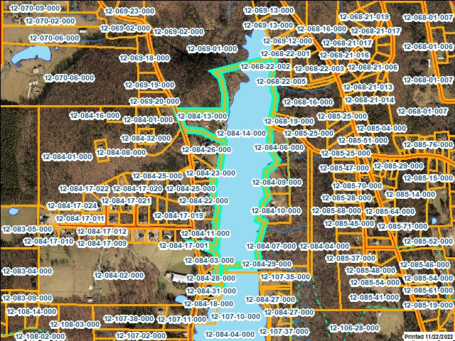
Whitfield County Tax Parcel Information
Owner and Parcel Information
Parcel Number
12-084-14-000
Realkey
10657
Property Record Card
Click Here
Property Record Card
Click Here
GIS Map
Map
Owner Name
PENDLEY THOMAS W & CAMI MOSS
Owner Address
1807 MARTHA'S BRIDGE RD
Owner Address 2
Owner Address 3
Owner City
DALTON
Owner State
GA
Owner Zip
30720
Latitude
34.82539055
Longitude
-84.9831598
Property Information
Class
Residential
Strata
Large Tract
Tax District
County
Neighborhood
Legal Description
PTTR7 GILFORD L MILES
Total Acres
33.45
Zoning
See GIS Map
GMD\Map Number
054
Subdivision
Subdivision Phase
Subdivision Section
0006
Subdivision Block
Subdivision Lot
Comments:
Appeals Information
Appeal Year
2003
Appeal Status
Resolved
Appeal Year
2008
Appeal Status
Resolved
Parcel Address
Parcel House Number
2266
Parcel Street Extension
Parcel Street Direction
Parcel Street Name
HAIGMILL LAKE
Parcel Street Units
Parcel Street Type
RD
Current Fair Market Value Information
Previous
169507
Current
240299
Land
224924
Residential Improvement
Commercial Improvement
Accessory Improvement
15375
Conservation Use Value
Historical Fair Market Value Information
2022
353281
2021
353281
2020
353281
Exemption Information
Homestead
S0
Preferential Year
Conservation Use Year
Historical Year
Historical Val
0
EZ year
EZ Val
0
GIS Quickmap
For the current GIS map of this parcel, click on the Quickmap to launch the interactive map viewer
Tax Commissioner Information
Before making payment verify the amount due with the Tax Commissioner’s office at 706-275-7510
Tax Bill Recipient
PENDLEY THOMAS W & CAMI MOSS
Year
2023
Parcel Number
12-084-14-000
Bill
228621
Exemption Type
Account No.
7101510
Millage Rate
0
Fair Market Value
169507
Assessed Value
67803
Prior Years Tax Data
Tax
Legal Description
PTTR7 GILFORD L MILES
Sale Date
9/2/2022
Taxes Due
1867.36
Taxes Due Date
12/20/2023
Taxes Paid
1867.36
Taxes Paid Date
12/12/2023 10:54:52 AM
Current Due
0
Back Taxes
0
Total Due
0
 
 
Commercial Structure Information
This parcel does not have any commercial structures to display
Residential Structure Information
This parcel does not have any residential structures to display
Accessory Information
Description
B GARAGE
Value
15375
Year Built
2000
Calculated Area
1632
Length
34
Width
48
Class
Residential
Strata
Production/Storage/Auxiliary
Sales Information
Grantee
PENDLEY THOMAS W & CAMI MOSS
Grantor
SMITH LUCRETIA
Sale Price
100000
Sale Date
5/8/2023
Deed Book/Page
6994 44
Deed Link
Click Here
Class
Residential
Strata
Small Tract
Reason
SALE BETWEEN ADJACENT PARCEL OWNERS
State
N
PT-61
PT-61 155-2023-000000
Comments
THIS SALE IF FOR ADDITIONAL 1.63A ONLY
Grantee
PENDLEY THOMAS W & CAMI MOSS
Grantor
MILES RICHARD EARL
Sale Price
940000
Sale Date
9/2/2022
Deed Book/Page
6956 266
Deed Link
Click Here
Class
Residential
Strata
Large Tract
Reason
CHANGES TO PROPETY AFTER SALE
State
N
PT-61
PT-61 155-2022-002830
Comments
WARRANTY DEED WITH ROS Additional Buyers: Pendle
Grantee
MILES RICHARD EARL
Grantor
Sale Price
0
Sale Date
5/1/1992
Deed Book/Page
2301 301
Deed Link
Click Here
Class
Residential
Strata
Large Tract
Reason
Value Change
State
N
PT-61
Comments