| Whitfield
County Tax Parcel Information |
|
Owner and Parcel
Information
|
| Parcel Number |
11-132-01-000 |
| Realkey |
3694 |
| Property
Record Card |
Click Here |
| GIS Map |
Map |
| Owner Name |
STRAIN ROAD PARTNERS LLC |
| Owner Address |
P O BOX 682 |
| Owner Address 2 |
|
| Owner Address 3 |
|
| Owner City |
DALTON |
| Owner State |
GA |
| Owner Zip |
30722 |
| Latitude |
34.93132969 |
| Longitude |
-84.93238274 |
|
| Property
Information |
| Class |
Residential |
| Strata |
Large Tract |
| Tax District |
County |
| Neighborhood |
|
| Legal Description |
363.72A LLS 121, 131, 132, 157, & 158- 11TH |
| Total Acres |
363.72 |
| Zoning |
See GIS Map |
| GMD\Map Number |
096 |
| Subdivision |
|
| Subdivision Phase |
|
| Subdivision Section |
0005 |
| Subdivision Block |
|
| Subdivision Lot |
|
| Comments: |
|
|
| Appeals
Information |
| Appeal Year |
2011 |
| Appeal Status |
Resolved |
| Appeal Year |
2014 |
| Appeal Status |
Resolved |
| Appeal Year |
2019 |
| Appeal Status |
Resolved |
|
|
|
| Parcel
Address |
| Parcel House Number |
0 |
| Parcel Street Extension |
|
| Parcel Street Direction |
|
| Parcel Street Name |
STRAIN |
| Parcel Street Units |
|
| Parcel Street Type |
RD |
|
| Current
Fair Market Value Information |
| Previous |
800599 |
| Current |
1050768 |
| Land |
1050768 |
| Residential Improvement |
|
| Commercial Improvement |
|
| Accessory Improvement |
|
| Conservation Use Value |
|
|
| Historical
Fair Market Value Information |
| 2023 |
921299 |
| 2022 |
731620 |
| 2021 |
731620 |
|
| Exemption
Information |
| Homestead |
S0 |
| Preferential Year |
|
| Conservation Use Year |
|
| Historical Year |
|
| Historical Val |
0 |
| EZ year |
|
| EZ Val |
0 |
|
|
 |
|
|
| GIS Quickmap |
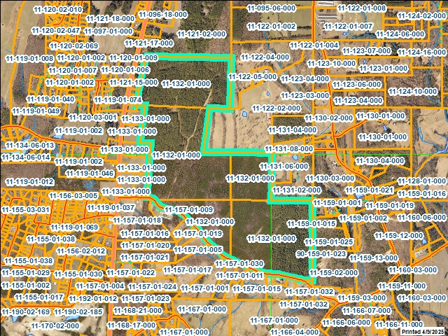 |
| For the current GIS map of this parcel, click on the Quickmap to launch the interactive map viewer
|
|
|
|
| Tax Commissioner Information
|
| Before making payment verify the amount due with the Tax Commissioner�s office at 706-275-7510
|
| Tax Bill Recipient |
STRAIN ROAD PARTNERS LLC |
| Year |
2024 |
| Parcel Number |
11-132-01-000 |
| Bill |
236241 |
| Exemption Type |
|
| Account No. |
7040168 |
| Millage Rate |
0 |
| Fair Market Value |
800599 |
| Assessed Value |
320240 |
| Prior Years Tax Data |
Tax |
|
| Legal Description |
363.72A LLS 121, 131, 132, 157, & 158- 11TH |
| Sale Date |
|
| Taxes Due |
7154.48 |
| Taxes Due Date |
1/20/2026 |
| Taxes Paid |
7154.48 |
| Taxes Paid Date |
12/26/2024 10:26:58 AM |
| Current Due |
0 |
| Back Taxes |
0 |
| Total Due |
0 |
| |
|
|
|
|
| Commercial Structure
Information
|
|
|
| This parcel does not have any commercial structures to display |
|
| Residential Structure
Information
|
|
|
| This
parcel does not have any residential structures to display |
|
| Accessory
Information |
|
|
| This
parcel does not have any accessories to display |
|
| Sales
Information |
| Grantee |
STRAIN ROAD PARTNERS LLC |
| Grantor |
DAVIS JOHN E |
| Sale Price |
0 |
| Sale Date |
6/6/2019 |
| Deed Book/Page |
6721 660 |
| Deed Link |
Click Here |
|
| Class |
Residential |
| Strata |
Large Tract |
| Reason |
SALE BETWEEN RELATIVES OR CORP AFFILIATES |
| State |
N |
| PT-61 |
PT-61 155-2019-002134 |
| Comments |
|
|
|
| Grantee |
DAVIS JOHN E |
| Grantor |
BOWATER NORTH AMERICA CORP |
| Sale Price |
1826083 |
| Sale Date |
6/27/2005 |
| Deed Book/Page |
4535 0079 |
| Deed Link |
Click Here |
|
| Class |
Residential |
| Strata |
Large Tract |
| Reason |
FAIR MARKET IMPROVED SALE |
| State |
N |
| PT-61 |
PT-61 155-2005-000000 |
| Comments |
4535-88 (QC) 6-27-05
INCL. 11-121-01-000, 11-131- |
|
|
|
|
 |