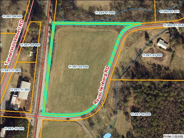
Whitfield County Tax Parcel Information
Owner and Parcel Information
Parcel Number
11-261-02-000
Realkey
5941
Property Record Card
Click Here
Property Record Card
Click Here
GIS Map
Map
Owner Name
THOMAS DONALD R
Owner Address
300 WADE RD
Owner Address 2
Owner Address 3
Owner City
DALTON
Owner State
GA
Owner Zip
30721
Latitude
34.88530876
Longitude
-84.97508041
Property Information
Class
Conservation Use
Strata
Large Tract
Tax District
County
Neighborhood
Legal Description
49.44A LL261 11
Total Acres
49.44
Zoning
See GIS Map
GMD\Map Number
Subdivision
Subdivision Phase
Subdivision Section
0010
Subdivision Block
Subdivision Lot
Comments:
Appeals Information
This parcel does not have any appeals
Parcel Address
Parcel House Number
0
Parcel Street Extension
Parcel Street Direction
Parcel Street Name
Parcel Street Units
Parcel Street Type
Current Fair Market Value Information
Previous
259347
Current
185153
Land
170523
Residential Improvement
Commercial Improvement
Accessory Improvement
14630
Conservation Use Value
47332
Historical Fair Market Value Information
2022
208519
2021
208519
2020
208519
Exemption Information
Homestead
S0
Preferential Year
Conservation Use Year
2017
Historical Year
Historical Val
0
EZ year
EZ Val
0
GIS Quickmap
For the current GIS map of this parcel, click on the Quickmap to launch the interactive map viewer
Tax Commissioner Information
Before making payment verify the amount due with the Tax Commissioner’s office at 706-275-7510
Tax Bill Recipient
THOMAS DONALD R
Year
2024
Parcel Number
11-261-02-000
Bill
237238
Exemption Type
Account No.
12549
Millage Rate
0
Fair Market Value
285281
Assessed Value
114112
Prior Years Tax Data
Tax
Legal Description
49.44A LL261 11
Sale Date
Taxes Due
693.94
Taxes Due Date
1/20/2025
Taxes Paid
693.94
Taxes Paid Date
1/31/2025 9:57:09 AM
Current Due
0
Back Taxes
0
Total Due
0
 
 
Commercial Structure Information
This parcel does not have any commercial structures to display
Residential Structure Information
This parcel does not have any residential structures to display
Accessory Information
Description
POULTRY HSE BROILER SOLID WALL
Value
7280
Year Built
1988
Calculated Area
16640
Length
40
Width
416
Class
Agricultural
Strata
Production/Storage/Auxiliary
Description
POULTRY HSE BROILER SOLID WALL
Value
7350
Year Built
1988
Calculated Area
16800
Length
40
Width
420
Class
Agricultural
Strata
Production/Storage/Auxiliary
Sales Information
This parcel does not have any sales to display